
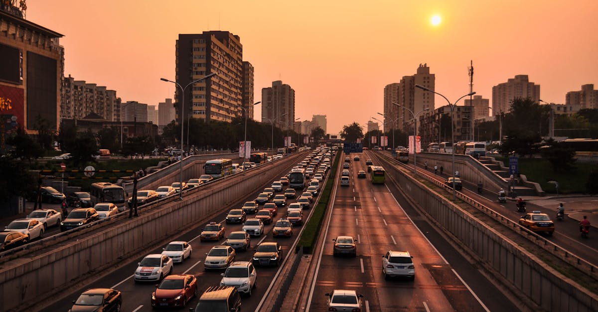
Since the recent start of construction on the A16 motorway in Pas-de-Calais, a small hamlet, Hardenthun, has been faced with an unprecedented and deeply disturbing situation. This once-peaceful village is now the scene of incessant traffic, with a car passing every two minutes, a flow over which residents have little control. This phenomenon, caused primarily by GPS-imposed routes, raises a fundamental question about the coexistence of new technologies and local life. Despite the presence of official diversion signs, drivers are increasingly relying on their mobile apps, creating chaos on a narrow municipal road unsuitable for such traffic.
The disruption is not limited to simple noise pollution or the stress caused to local residents: it affects safety, infrastructure, and even the hamlet’s power supply. A series of accidents and power outages caused in particular by a crane falling after a collision with a semi-trailer demonstrate the massive impact of poorly managed traffic. Moreover, the growing prevalence of GPS applications is forcing a considerable number of vehicles, including heavy goods vehicles, onto roads where their use is not only dangerous but also often illegal.
Faced with these observations, the mayor of Hardenthun, Olivier Leroy, views this local crisis as a striking example of the drawbacks of automated guidance technologies when they fail to take into account the reality on the ground. While he advocates for bans aimed at limiting the circulation of heavier vehicles, public debate is opening more broadly on the need for better integration of connected technologies in our rural areas. The objective: to restore peace and security in a hamlet transformed into a necessary passageway, while considering sustainable solutions to prevent other villages from suffering the same fate.
The constant flow of vehicles: a GPS route crisis in a hamlet
In Hardenthun, the situation is dire. Since June 1st, approximately every two minutes, a new vehicle has been passing through this village, which is crossed by a municipal road only three meters wide. This road, unsuitable for heavy traffic, is saturated by a constant stream of cars, vans, and heavy goods vehicles, all diverted by their GPS navigation systems. These popular applications, like Waze or Google Maps, are designed to prioritize the fastest route, but they do not always take into account environmental and local constraints.
This explosion in traffic is causing a real deterioration in residents’ quality of life, as well as an increased risk of accidents. Contrary to the official detour signs put up by the Interdepartmental Roads Directorate, which are often barely visible or deemed unreliable, drivers blindly trust the devices they rely on for their daily commutes. This problem perfectly illustrates the phenomenon of « AutoTrafiquants »: a stream of vehicles navigating secondary routes imposed by technology without consideration for the impact on the areas they pass through. An impact exacerbated by heavy goods vehicles The massive passage of heavy goods vehicles is exacerbating the deterioration of the situation. The mayor notably mentions the collision between a semi-trailer and a crane, an incident that resulted in the crane falling over and a power outage in part of the village. These vehicles, often weighing over 3.5 tons, should not be using these small rural roads. Yet, due to a lack of clear signage or GPS errors, they systematically take this route. This situation not only overloads infrastructure but also creates constant stress for residents exposed to the incessant noise and the risk of accidents. The safety of local residents is thus compromised while the nuisance from
Road Noise
intensifies.
🚚 High frequency of heavy goods vehicles on a narrow road ⚠️ Increased number of traffic accidents in the hamlet 🔌 Power outages caused by collisions
- 🚗 Disrupted traffic for private vehicles
- 📉 Deterioration of local quality of life
- Event
- Consequence
- Date
| Impact on the village | Start of work on the A16 | Vehicle rerouting via GPS | June 1, 2025 |
|---|---|---|---|
| Massive increase in traffic | Semi-trailer-crane collision | Partial power outage | Early June 2025 |
| Increased safety risks | Increased number of accidents | Increased surveillance requested | June 2025 |
| State of alert among residents | Official diversion poorly followed | Use of unsuitable GPS routes | Since June 2025 |
| Uncontrolled influx of vehicles | The situation is also causing a snowball effect in neighboring villages, where drivers are seeking alternative routes based on informal navigation advice via GPS apps and the TraficSavant community. | https://www.youtube.com/watch?v=DD9N5S7a5-w | Multiple consequences for safety and local life in Hardenthun |
The constant passage of vehicles is profoundly disrupting the lives of residents. Beyond noise pollution, the major issue is safety. The mayor of Hardenthun is sounding the alarm about the high accident-prone condition of this municipal road, which is now overloaded well beyond its capacity. Numerous incidents have been reported, with drivers often disoriented and nervous, increasing the risk of accidents. Residents must be extra vigilant when leaving their homes and crossing the road. This situation also poses accessibility problems for emergency services and rescuers, who can be delayed by the constant traffic congestion. Impact on Infrastructure and Power GridsAmong the material consequences, most of the local infrastructure has suffered damage. The impact that caused the crane to fall led to a temporary power outage in one area of the hamlet. This type of incident tangibly demonstrates the impact of the flood of vehicles on essential equipment. Maintenance becomes more costly and network reliability is less assured.
💡 Risk of power outages
🛠 Increased infrastructure repair costs
🚑 Difficulties in emergency response
🧘 Threat to local peace and quiet
Consequence
Detail Short-term impact Long-term impact
- Frequent accidents
- Semi-trailer and crane collisions, numerous incidents
- Injuries, property damage
- Degraded image, reduced attractiveness
- Power outages
| Equipment falling onto power lines | Temporary power losses | Network reinforcement required | Excess maintenance costs |
|---|---|---|---|
| Rapid deterioration of roads and equipment | Increase in municipal budget | Need for significant investments | Risks for emergency services |
| Road congestion | Potential response delays | Emergency plans to be revised | This situation reveals the limitations of current guidance systems. The classic model of GPS applications, focusing on speed, is no longer sufficient. We must now consider innovative solutions that better take into account the fragility of the areas crossed. |
| Discover effective strategies to optimize your online traffic, increase your visibility, and attract more visitors to your site. Maximize your digital presence with proven techniques. | https://www.youtube.com/watch?v=duBm6FK2qWE | The role of GPS and its unexpected consequences on small villages | GPS applications have revolutionized the way drivers travel. Their primary objective is to optimize routes, reduce travel times, and avoid traffic jams. However, this optimization often relies on incomplete data and neglects certain criteria related to safety and the character of the roads crossed. |
| In Hardenthun, the symptom is clear: the GPS Impact has led to an excessive flow of vehicles on an unsuitable road, causing congestion that did not exist before. This situation is not isolated. In several regions of France and even abroad, small villages are witnessing a similar invasion caused by routes dictated by navigation technologies. | Route choices that ignore local constraints | GPS application algorithms prioritize travel speed or avoid certain congested areas. They then direct traffic toward secondary streets, often narrow, rural, or not designed to handle heavy traffic. Drivers, seeking to save time, rely almost blindly on these directions, leading to congestion and increased risks. | The problem goes beyond simple inconvenience. It sometimes leads to the deterioration of these roads, increasing noise pollution, and a feeling of abandonment among local communities. The latter are now demanding greater responsibility from navigation solution providers, here called SatNav Solutions. |
📱 Excessive prioritization of speed
🛤 Inadequate official signage
🤖 Need for smarter and more responsible algorithms
GPS advantage Observed disadvantage Local impact
Specific example
Time saving
Driving through unsuitable areas Congested traffic in Hardenthun3-meter narrow street
- Traffic jam avoidance
- Flow of vehicles on secondary roads
- Deterioration of infrastructure
- Heavy goods vehicle-crane collision
- Increased accuracy
| Ignorance of local traffic restrictions | Increased risk of accidents | Heavy goods vehicles on prohibited routes | Intuitive interface |
|---|---|---|---|
| Challenge for territorial management | Anger of local residents | Request for traffic ban | These issues send a strong signal to both authorities and digital industry players to provide tools that are more respectful of the rural context, promoting a better balance between technological innovation and respect for the local way of life. |
| Local actions and solutions considered to restore peace in the hamlet | Faced with this incessant barrage of vehicles, local officials and residents have begun to take action to protect Hardenthun. One of the first steps is to establish traffic restrictions, particularly to limit the transit of heavy goods vehicles, which was Mayor Olivier Leroy’s main concern. | The installation of more visible signs indicating the official detour is also being considered, in order to redirect drivers to more suitable routes. However, these measures alone will not be sufficient as long as GPS applications do not take these provisions into account, hence the need to collaborate with SatNav Solutions providers. | Community Initiatives and Information Campaigns |
| In Hardenthun, residents are organizing to raise awareness among drivers of the problems they are causing. Leaflets are being distributed, public meetings are being held, and the local press is reporting the situation to alert a wider audience. These initiatives aim to stimulate behavioral change, encouraging careful and responsible driving. | 🛑 Ban on vehicles > 3.5 tonnes | 🚧 Improved road signage | 📢 Targeted information campaigns |
| 🤝 Dialogue with GPS providers | 🌱 Promotion of the EcoHameau concept | Measure | Responsible |
Goal
Status
Heavy goods vehicle restrictions
Town Hall Reduce risks and nuisancesUnder implementation
Enhanced signage
DIR (Interdepartmental Roads Directorate)
- Clarify the official detour
- Upcoming project
- Information for drivers
- Residents and town hall
- Change behaviors Already launched
| Dialogue with SatNav Solutions | Town hall and local associations | Adapt GPS routes | Under discussion |
|---|---|---|---|
| Beyond the immediate constraints, some are considering going further by considering technological solutions integrated into GPS systems to avoid passing through sensitive areas, based on data updated in real time by municipalities. This collaboration would represent a new horizon for smarter and more respectful management of rural roads and | CarSlowdown | . Discover how to optimize your online traffic and increase your visibility. Learn the best strategies to attract visitors to your site and improve your digital performance. | Challenges for the future: towards a harmonious coexistence between technology and rural life |
| This crisis experienced by Hardenthun illustrates how the balance between innovation and respect for rural areas has become more important than ever. The proliferation of digital tools in driving, while bringing real benefits, can cause profound dysfunctions if it occurs without consultation or local adaptation. | Current debates highlight the need for GPS applications to more accurately consider territorial constraints, calling for a renewal of these models. For the mayor, as for many experts, the key lies in strong collaboration between local authorities, digital industry players, and users, in order to develop navigation systems that combine speed and safety while also respecting the living environment, to restore a | HameauEnPeix | . |
| Integrating New Technologies in Rural Areas | Many challenges remain. How can we reconcile efficiency and | EcoHameau | ? How can we manage |
| Car Flow | in villages without compromising tranquility? Satellite-based solutions, artificial intelligence, and collaborative GPS updates could provide suitable solutions. 🌐 Development of algorithms that take into account road width and weight limits | 📊 Real-time monitoring of localized traffic flows | 👥 Increased consultation with rural users |
♻️ Encouragement of soft mobility and slowdowns 📱 Strengthened collaboration with GPS providersObjective
Expected benefit
Deadline
Reduction of inappropriate traffic Installation of filters on GPS routesLess nuisance and accidents
2026
Preservation of rural infrastructure Weight and speed controls Improved road sustainability 2025-2027 Promotion of local safety
- Information and awareness
- Improved village-car coexistence
- Ongoing
- Maintenance of the local economy
- Controlled organization of traffic flows
| Support for businesses and residents | 2026 | While villagers are still waiting for concrete relief, the Hardenthun experience offers a case study that will shed light on other communities facing the same challenges and guide public policies towards a good balance between technology, security and quality of life. | Frequently asked questions about vehicle diversion in small hamlets |
|---|---|---|---|
| Why do GPS direct vehicles onto narrow roads in rural areas? | Algorithms often favor the shortest travel time without always integrating the specific characteristics of the roads (width, weight limitations), which leads to unsuitable routes in certain cases. | Are there solutions to protect villages from this excessive traffic? | Yes, measures such as weight restrictions, better signage and collaboration with GPS providers can limit this phenomenon. |
| How can residents act in the face of this situation? | They can mobilize locally to inform drivers, dialogue with authorities and work with associations to promote sustainable alternatives, such as the campaign | EcoHamlet | . |
| What is the responsibility of GPS navigation companies in this problem? | These companies must further integrate local constraints into their algorithms to avoid directing traffic towards dangerous or inappropriate routes. | What are the prospects for the future in the face of this disruption? | The development of more intelligent systems, integrating real-time data and better consultation with communities, will make it possible to better balance security, speed and quality of life. |
| To find out more about this issue, consult the following articles: | This town invaded by cars is subject to Waze’s recommendations | Diversions around the A16: drivers diverted to a hamlet of Marquise | The diversion sows chaos: the hamlet is overwhelmed with lost cars and angry drivers |
A street brutally blocked to cars by residents